
Introducing PopFlows: a new application to explore residential mobility across Europe
Understanding why people move between places is key to making sense of rural change and territorial development. RURALITIC has launched PopFlows, a new openly accessible online application designed to make residential mobility data easier to explore and communicate. Covering ten countries and up to 30 years of historical data, PopFlows provides researchers, policy makers, planners, and interested citizens with intuitive tools to examine mobility patterns across territories and over time.
Developed by RURALITIC consortium partner INRAE in cooperation with the data agency Flowt, the application draws on national statistical systems to compute mobility flows and migratory balances. It contributes directly to RURALITIC’s broader objective of improving understanding of the drivers of rural attractiveness and how these have evolved over time, particularly in the context of Covid-19 and public policy interventions.
Modules and use cases
PopFlows brings together three complementary modules that allow users to analyse population movements from multiple perspectives, combining geographical visualisation with statistical insight.
- The Territories module offers a spatial overview of residential mobility indicators such as arrivals and departures per 1000 residents, as well as migratory balances across European countries. Users can explore data at different territorial levels, enabling comparisons between rural, intermediate, and urban areas, as well as across years.
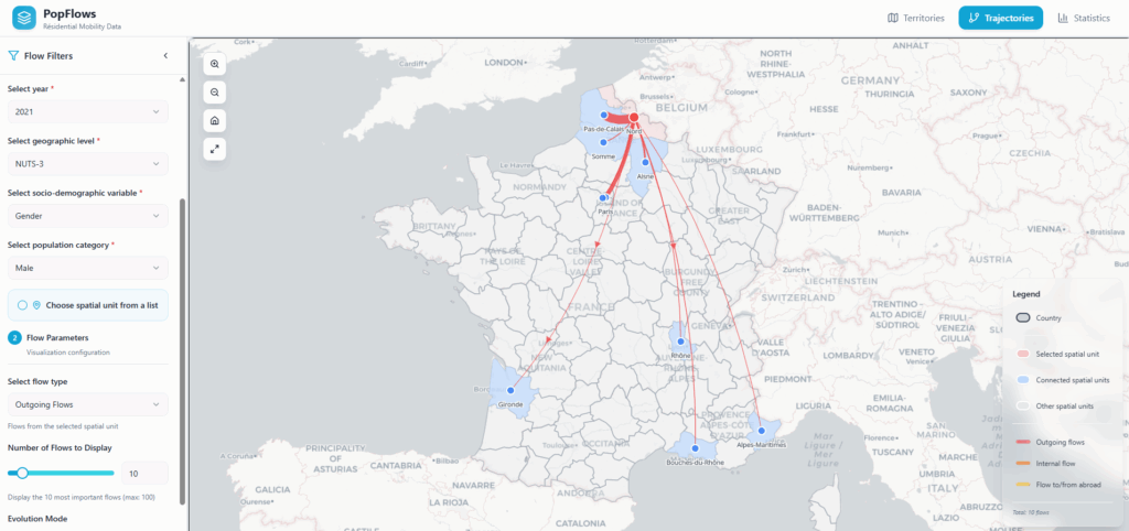
- The Trajectories module focuses on origin-destination relationships. It visualises net population flows between territories, highlighting major incoming and outgoing connections and mobility corridors. As in the Territories module, users can refine the analysis by year and by socio-demographic characteristics such as age, gender, and citizenship. An evolution mode allows direct comparison of flows between two periods, enabling major events or policy changes to be linked to shifts in mobility patterns.
- The Statistical analysis module provides a deeper examination of residential mobility trends through time series of selected indicators. After selecting the territory and filters, users can generate outputs showing how population flow indicators evolve year by year, useful for supporting academic analysis or policy evaluations.
Supporting stakeholders through open science
PopFlows reflects RURALITIC’s commitment to open science and to supporting the wider community of researchers and practitioners working on rural issues. The application is freely accessible and designed to evolve through continued use and feedback. It is particularly valuable for users who require reliable and comparable evidence to analyse mobility patterns.
For researchers, PopFlows offers harmonised mobility data across countries, time periods, and spatial scales, enabling more robust demographic analysis. At the same time, the data can be read through a policy lens, helping decision makers move beyond isolated indicators to understand how mobility patterns shape territorial development. For urban and regional planners, it helps clarify how population movements interact with infrastructure needs, housing demand, and service provision.
Understanding the drivers of rural attractiveness
PopFlows will play a central role in upcoming RURALITIC research activities aimed at disentangling the pull and push factors that drive residential attractiveness, with a specific focus on changes associated with Covid-19.
These insights will feed subsequent analyses within RURALITIC and be complemented by qualitative research with local stakeholders, adding depth by capturing perceptions, motivations, and lived experience. This combined research will be used to explore why people move, how residential and economic mobility interact, and what this means for rural areas.
As the project progresses, the PopFlows application will be further enriched with new indicators related to housing and land pressures, well-being, and policy impacts. In this way, PopFlows functions as a living research infrastructure, translating complex data into usable evidence and ensuring that project findings remain relevant to those engaged in planning and understanding the future of rural territories.
To stay informed about project developments and outputs, follow RURALITIC on BlueSky and LinkedIn. Our scientific publications are available on Zenodo.